Idioma:


Agenda:
Enlaces Webs:

La mejor para estar al día de la volcanología y sismicidad en Canarias

Instituto Tecnológico y de Energías Renovables![]()
Instituto Jaume Almera (CSIC - Barcelona)![]()
Vigilancia volcánica en Canarias![]()
Sociedad Geológica de España
International Association of Volcanology and Chemistry of the Earth's Interior![]()
Servicio geológico de EEUU![]()
Volcanes del Mundo![]()
Mapa volcanes activos![]()
Unión Internacional de Geodesia y Geofísica
How Did Iceland Form?
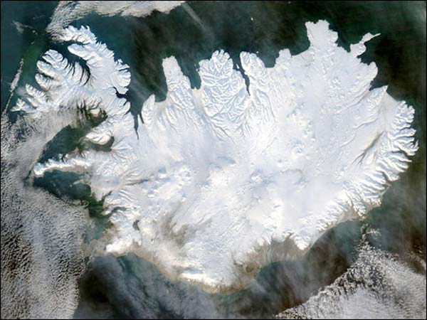
Credit: NASA/Earth Observatory/Aqua satellite
The explosion of a volcano on the tiny island nation of Iceland late Saturday night is a part of the continuing process that created the spit of land in the middle of the North Atlantic Ocean.
Iceland sits smack dab on the front lines of the battle between pieces of the Earth's crust that move around and cause earthquakes and volcanoes as they slide past, under and over each other. The small European nation is situated on the Mid-Atlantic Ridge, a seam in the Earth's surface under the North Atlantic Ocean where the Eurasian and North American plates slide apart.
The Ridge includes a deep rift valley that runs along its axis, from which magma from Earth's roiling mantle, or the slab of material just below the planet's outer layer called the crust, seeps upward and erupts from the seafloor as lava. That lava hardens into new crust atop the two diverging plates. The plates move apart along the Mid-Atlantic Ridge an average of about 1 inch per year (2.5 centimeters per year), or 15.5 miles (25 km) in a million years, according to the United States Geological Survey.
Iceland's position means that it is a hotspot for geologic activity, including earthquakes, volcanic eruptions and geysers (which provide Iceland with abundant geothermal energy). The island nation has more than 200 volcanoes. It was its volcanic activity that is thought to have created Iceland.
The evolution of the island continues through the same processes that
created it, with volcanoes erupting every so often and new fissure
appearing along their slopes. The volcano that erupted this weekend,
called Eyjafjallajokull (AYA-feeyapla-yurkul), hadn't erupted in almost
200 years, according to press reports. [See other volcanoes erupting]
One of the youngest islands in the world formed in much the same way as Iceland: The island of Surtsey rose above the ocean in a series of eruptions between Nov. 8, 1963 and June 5, 1968.
Iceland is not as harsh a place as it might be. It's closeness to the Arctic Circle is softened by the tail end of the Gulf Stream Current, which flows up through the Atlantic Ocean bringing heat from the tropics, according to NASA. Large portions of Iceland thaw each summer. Still, with widespread lava fields, cold deserts, and the tundra that dominates the northern parts of the island, only about 20-25 percent of the island is habitable, mostly along the south and eastern coasts, scientists say.
(By Andrea Thompson, Senior Writer)
![]()